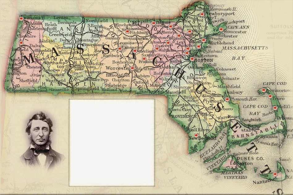
This site uses historical maps to organize and interpret documentary materials related to Thoreau's travels throughout Massachusetts. Clicking on the red map pins will open pages containing notes, images, quotes, and links to additional resources on Thoreau's contributions to American political, social, economic, and environmental thought. To view Thoreau's adventures in cartography, please click on Thoreau's Maps at the top of this page.
Learn More
-
34
641
-
63
484
-
73
537
-
83
703
-
90
601
-
90
401
-
104
567
-
118
646
-
138
630
-
145
595
-
167
593
-
127
57
-
142
376
-
180
612
-
209
416
-
127
531
-
145
497
-
151
425
-
179
454
-
279
840
-
298
861
-
308
722
-
425
621
-
552
878
-
50
60
Newburyport
Thoreau lectured on his excursions to Cape Cod at Market Hall in Newburyport on December 6, 1850. Read more...Chelmsford
The Thoreau family lived in Chelmsford from 1818-1821. Read more...Lowell
Lowell figured significantly in Thoreau's life, both as a site of lectures and a symbol of industrial expansion. Read more...Gloucester
Thoreau delivered "Economy-Illustrated by the Life of a Student," an early Walden lecture, here on December 20, 1848, Read more... South Danvers
Thoreau lectured on his travels on Cape Cod at the South Danvers Lyceum on February 18, 1850. Read more...
Fitchburg
Thoreau gave a lecture entitled "Walking, or the Wild" in Fitchburg on February 3, 1857. Read more...Bedford
Thoreau gave his lecture on "Wild Apples" at the Bedford Lyceum on February 14, 1860. Read more...Salem
Nathaniel Hawthorne arranged for Thoreau to lecture in Salem on two occasions, November 22, 1848 and February 28, 1849. Read more... Lynn
Thoreau delivered "Autumnal Tints" at Frazier Hall in Lynn on April 26, 1859. Read more...Medford
Thoreau read "Economy," a lecture that evolved into a chapter in Walden, in Medford on January 22, 1851. Read more...Cambridge
Thoreau attended Harvard College here from 1833 to 1837 and returned often to use the library. Read more...Pittsfield
In 1844, after a night on Mt. Greylock, Thoreau joined Ellery Channing here for a trip to the Catskills. Read more...Mt. Wachusett
After he hiked to Mt. Wachusett in July 1842, Thoreau turned his notes into "A Walk to Wachusett." Read more...Boston
Thoreau gave several lectures here between 1844 and 1859 including his defense of John Brown. Read more...Worcester
Thoreau lectured more frequently in Worcester than in any other place except Concord. Read more...Lincoln
Thoreau spent considerable time in Lincoln including six weeks living in a hut at Flint's Pond in 1837. Read more...Concord
Explore Thoreau's travels in Concord. Read more...Clinton
In 1851, Thoreau lectured here in response to an invitation from the Bigelow Charitable Mechanics Institute.Framingham
Thoreau delivered a fiery speech, "Slavery in Massachusetts, here on July 4, 1854. Read more...Provincetown
Thoreau took four trips to Cape Cod and recorded a wealth of entertaining observations. Read more...Truro
Thoreau lodged at the Highland Lighthouse during July 1855 while he studied the natural history of Cape Cod. Read more...Plymouth
Thoreau delivered his lecture on "Moonlight" here on October 8, 1854. Read more...New Bedford
Thoreau gave one of his most popular lectures, "What Shall It Profit," at the New Bedford Lyceum on December 26, 1854. Read more...Nantucket
Thoreau delivered "What Shall It Profit" at the Nantucket Lyceum on December 28, 1854. Read more...Mount Greylock
Thoreau made his first trip to Mt. Greylock in 1844. Read more...