Read about Champlain at the John Carter Brown Library. |
The Champlain Maps
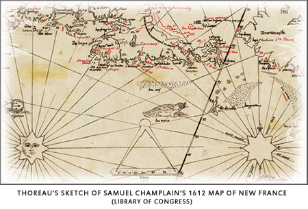
"In Champlain's Voyages...there is a map of [New England] made when it was known to Christendom as New France...a map extending from Labrador to Cape Cod and westward to the Great Lakes, and crowded with information, geographical, ethnographical, zoological, and botanical... This, taken together with the many separate charts of harbors and their soundings on a large scale...makes this a completer map of the New England and adjacent northern coast than was made for half a century afterward." Although Thoreau's interest in maps has long been well known, John Hessler, a senior cartographer at the Library of Congress and member of the Royal Geographical Society, opened a new realm of study when he tracked down seven maps that Thoreau listed on the back cover of his unpublished Canadian notebook. Among Hessler's finds, the most significant was Thoreau's heavily annotated and updated composite of several maps, including Champlain's 1612 map of "New France." Having pored over Thoreau's composite maps and cartographic notes, Hessler underscores Thoreau's previously unrecognized role in the evolution of geographical studies in North America: "In Thoreau’s map sketches and in the detailed commentary that he wrote about each them in his notebooks, I see the work of a very modern historical geographer. I see someone who is trying to reconstruct the lost landscape of New England, not only topographically, but also culturally. Thoreau is very concerned with the Native American population, their habits and living conditions and looks to maps to help him imagine what came before both linguistically and geographically. In his cartographic explorations Thoreau expresses himself in such detail that he can be considered as perhaps the first truly American geographer, who not only realized that the landscape that he was living in was a dynamic construction, but also that each cultural community and each generation imposed their own physical and cognitive map on the natural world they lived in." |


